
Nestled between the Memorial Union and the Farmer Education Building on the Arizona State University Tempe campus is the Moeur Building. To the passer-by, it looks like any other building at ASU, with students and professors roaming in and out of its many classrooms.
But one step into the building and you are transported far away from campus and onto a whole different planet — Mars, to be exact.
In the center of the building's entrance way, you are greeted by a large model rover (about the size of a Barbie Jeep) that is sampling rocks on a model of Mars. Continuing on into the building, you find miniature model spacecrafts and orbiters made out of cardboard that are wrapped in paper to make them look more like their life-size counterparts. There is also a collection of small and colorful rocks from around the world and a few old computers that appear in most space exploration movies.

These beautiful and colorful pictures are the product of an ASU-led research project headed by Philip Christensen, a Regents Professor of Geological Sciences in the School of Earth and Space Exploration.
Getting Started
The project began in a very innocent way, says mission planner Jonathon Hill, who has been part of the project since the beginning. Hill says ASU won a competition to build the Thermal Emission Imaging System (THEMIS) from NASA because Christensen had already worked with infrared instruments for NASA before.
Hill, who graduated from ASU in 2005 with a degree in aerospace engineering and got his master's in 2009, says he was excited when Christensen asked him to be a part of the project. Before the project started, Hill says he had heard of Christensen, but it wasn't until Christensen asked him to work on the project that he really met him.
"Dr. Christensen asked for help with this project like it wasn't a big deal, it was just another project," Hill says. "We both knew no one had ever done it, but we thought we could do it."
Following that conversation, Hill says the real work began.
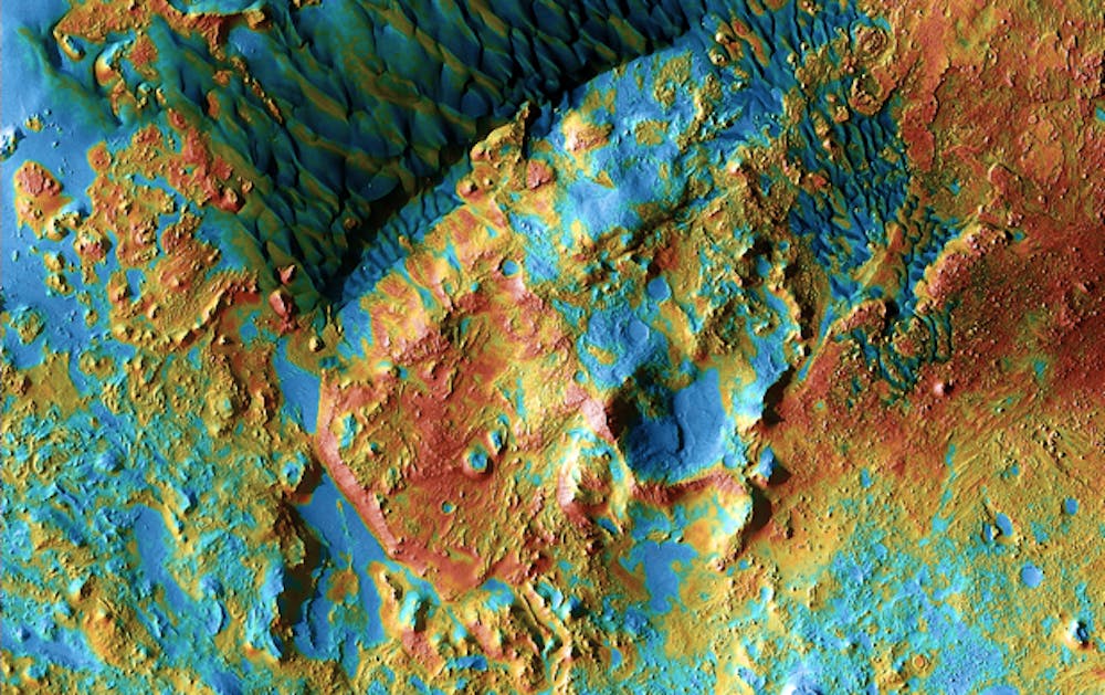
To improve the picture quality and the map of Mars, THEMIS was developed. THEMIS captures both visible light (like the pictures a point-and-shoot camera takes) and infrared images, which show temperature differences and combines them into a mosaic. This mosaic ends up being a better, more detailed picture than just a visible light picture.
Christopher Edwards, a doctoral candidate at ASU who also worked on the project, says his original interest in Mars took on a whole new life through the THEMIS images.
"I am and was interested in solving some geologic problems on Mars, like how did the crust form and what is it made of," Edwards says. "[But] it's interesting because making this map has provided new views and ideas that I didn't have even a hint of before the global mosaic."
After nearly a decade of research, THEMIS compiled over 60,000 visible light and infrared images of Mars surface. Aboard NASA's Mars Odyssey orbiter, THEMIS has lead to significant improvement of modern maps of Earth's neighboring planet, Hill says.
At one point during the project, Hill says THEMIS had compiled over seven terabytes (7,000 gigabytes of data, which is about 110 64GB iPod touches or enough space to store 1,540,000 songs). Along with discovering several new things about Mars and its surface, "We also found all sorts of wonderful ways to break computers," Hill says.
Advancements in Science
Before THEMIS and the Odyssey, the best images of Mars showed only the elevation levels on the planet, such as where there were mountains or valleys, Hill says. Today the images show far more detail such as the minerals that can be found on the surface, as well as what the temperatures are like.
"This is more than just a pretty picture," Hill says. "You can actually derive some scientific data from it. Everything is exactly where it should be and everything is very scientifically calculated."
Emily McBryan, an aerospace engineering junior who worked as a summer intern on the project, says the team actually mapped Mars twice — once during daylight hours and once during nighttime hours. This ended up producing two different sets of data about temperatures on Mars.
"This map was made so scientists could study Mars and understand the planet as well as we understand Earth," McBryan says.
Along with making it easier for scientists to study the surface, the THEMIS images have also been picked up by Google Mars and now anyone around the world can can view the improved maps of Mars.
The THEMIS images and the global mosaic of Mars have also played a role in making rover landings on Mars more successful.
By enhancing images of the Mars surface and being able to tell what the surface texture is like (rough or smooth, a terrain of boulders or sand), rover mission planners can plan their landings well, Hill says.
"People all around the world are enabled to do their science better because of what we did," Hill says.
The Future
NASA has already scheduled a fourth mission for THEMIS on the Odyssey and Hill says the next big goal is to make a geological map of Mars that shows much more than just temperature. The next map will look at the minerals present on the Mars surface.
The ASU team is excited for the future project and can't wait to see what new things they can learn this time.
"Looking at all the images changed my perspective," McBryan says. "Before, the idea of space travel and exploration through the solar system was a far-off dream, but seeing the landscape and how much we could do with these pictures made Mars seem a lot closer. In all my dreams, I could never have imagined the majestic features that these images brought me."
McBryan also expressed her enthusiasm for future students who may be interested in studying the stars, the galaxy and even the universe.
"Dream ridiculous dreams and work towards them no matter what," McBryan says. "The stars are not that far away. The sky is not the limit, rather [it's] the beginning."
Contact the reporter at beth.easterbrook@asu.edu.