The seconds drag on as I obsessively glance at the clock. The few remaining minutes of class stand between me and a difficult, exhilarating and possibly dangerous adventure.
I’m sitting in synoptic meteorology, learning about the complexities of the atmosphere and the processes that create every type of weather — but right now, I want to be in it, not learning about it.
Class is dismissed, and I’m jogging out the door. I hurry to my car, which is packed full of cameras, mounts and other equipment, and I zip onto the freeway. I hope to travel hundreds of miles across the hot Arizona desert to witness and capture a violent force of nature on camera.
As miles pass, distant clouds catch my eye. The crisp edges of billowing cauliflower-shaped cumulus congestus clouds signal an atmosphere ready to set off an unthinkable amount of energy.
Simple thunderstorms release more energy than the atomic explosion in Hiroshima. To predict where storms form, meteorologists study weather patterns and use supercomputers to simulate the atmosphere.
Forecasting storms to chase is as much of an art as it is a science.
I started photographing storms from my driveway when I was 13 and started chasing as soon as I was old enough to drive. I use a combination of my own experience and basic weather knowledge to analyze data and road networks. I look for the best combination of atmospheric energy combined with elevated roads for better views of a storm.
Monsoon season has been challenging this summer, as storms have rarely wandered north enough to reach Phoenix. On this day, the storms are forecast in the mountains and valleys near Tucson, so that’s where I’m headed.
Two and a half hours into the journey, I stop to reassess.
I’m sitting in a low spot south of Tucson and dark skies are rumbling with distant thunder to the south. I’m not in the right place, but I can wait it out.
A successful storm chase relies on a cascade of quick decisions and luck. One wrong turn or a mistimed bathroom break can be the difference between getting the perfect picture or going home empty-handed.
Clouds are gathering not far to the north, and as soon as they start dropping lightning bolts, I’m back on the freeway, racing toward them. I’m desperately looking for a viewpoint and eventually find one near a home on a hill.
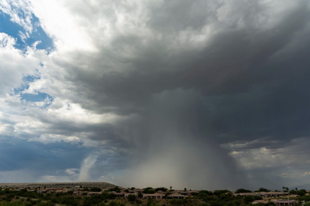
The view is spectacular: a towering thundercloud is unleashing a deluge of rain onto the desert floor. The sight is punctuated by staccato lightning bolts and even a tornado look-alike, a gustnado caused by the downward rushing air from the storm.
I suddenly feel a blast of cool wind that tempers the oppressive heat. The chilly gusts hint that this storm is in its final stage of life before it finally collapses.
I have to plan ahead like a chess player analyzing the board.
“Where do I need to be for sunset, what are the storms doing next, how long will the Tucson traffic hold me up?”
I decide to head west to hopefully catch new storms as the sun sets.
While the sun approaches the horizon, rain starts to fall. Equipped with Doppler radar on my phone, I plan a route to maneuver around the rain.
Rain can be a major problem for photographers, the water can damage a camera and obscure the lens.
Within a few minutes, the setting sun shines orange across the sky while piercingly bright lightning connects with a telephone tower no more than a quarter-mile away — I can feel the surging static electricity energize the hair on my arms inside my car. I’m too close, but I’m desperate to capture this apocalyptically beautiful scene.
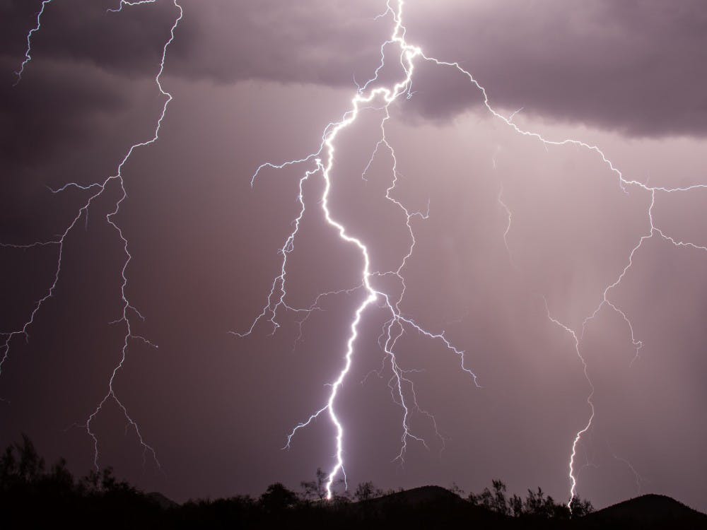
I pull off the road and set up my camera’s shutter to stay open for several seconds, hoping that a bolt will land in front of the lens. In an instant, I see tendrils of electricity travel toward a hill about a mile in front of my camera. A booming cacophony of thunder follows, and for a moment I’m terrified the camera didn’t catch it, until its screen illuminates, showing the entire strike and all the detailed tendrils branching off of the primary bolt. I’m elated and captivated by the image on the screen.
This moment sums up my love of nature and storm chasing. The technical and artistic challenges involved in capturing something so powerful and majestic make all the hard work worth it.
When all the storms are dissipated, I start my long trek home feeling accomplished and content with only one thing left on my mind: “Where will the storms be tomorrow?”
Reach the reporter at cscragg@asu.edu or follow @monsoonchaser on Twitter.
Like State Press on Facebook and follow @statepress on Twitter.